Ongoing Research Topics & Past Research
Snowmelt Processes
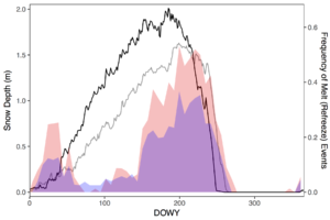
Identifying the presence of liquid water in the snowpack (including its frequency and timing) is important for tracking climate change impacts, informing snowpack and hydrological modeling, and supporting satellite estimates of snow water equivalent. Our group has developed a method to identify snow melt-refreeze transitions from passive microwave satellite data, allowing for tracking of wet snow at local to global scales.
Enhance! Increasing Spatiotemporal Resolution of Satellite Snowmelt Observation. (2022). Abstract 412-06. George Duffy, Angela Rienzo, Elias Deeb, Carrie Vuyovich, & Sam Tuttle. Oral presentation at the at the Frontiers in Hydrology Meeting, San Juan, Puerto Rico.
Evaluating Passive Microwave Snowmelt Detection Methods with Ground Snow Observations. (2022). Angela Rienzo, Elias Deeb, Carrie Vuyovich, & Sam Tuttle. CMOS-CGU-Eastern Snow Conference Joint Congress, virtual.
Timing of Snow Melt and Refreeze Events in the Northern U.S. (2003 to Present) from Passive Microwave Satellite Observations. (2020). Sam Tuttle oral presentation at 100thAmerican Meteorological Society (AMS) Annual Meeting, Boston, MA.
Enhanced identification of snow melt and refreeze events from passive microwave brightness temperature using air temperature. (2019). Sam Tuttle & Jennifer Jacobs, Water Resources Research.
Estimation of Snow Water Equivalent
Snow water equivalent is a measure of how much water is stored in the snowpack. Snow is a crucial water resource for much of the world (e.g. western U.S., central Asia), so knowledge of snow water equivalent is important for water resources management, as well as for snowmelt flood prediction. Our group has examined a number of methods to estimate snow water equivalent, with a special focus on flood forecasting applications in the north central U.S.
Using Cosmic Ray Neutrons for Snow Water Equivalent Estimation of a Prairie Environment in Central Montana. (2022). Abstract 418-07. Madison Woodley, Eric Sproles, Jed Eberly, & Sam Tuttle. Oral presentation at the Frontiers in Hydrology Meeting, San Juan, Puerto Rico.
Improvement of operational airborne gamma radiation snow water equivalent estimates using SMAP soil moisture. (2020). Eunsang Cho, Jennifer Jacobs, Ronny Schroeder, Sam Tuttle, & Carrie Olheiser, Remote Sensing of Environment.
Comparison of satellite passive microwave with modeled snow water equivalent estimates in the Red River of the North Basin. (2019). Ronny Schroeder, Jennifer Jacobs, Eunsang Cho, Carrie Olheiser, Michael DeWeese, Brian Connelly, Michael Cosh, Xinhua Jia, Carrie Vuyovich, & Sam Tuttle, IEEE Journal of Selected Topics in Applied Earth Observations and Remote Sensing.
Intercomparison of Snow Water Equivalent Observations in the Northern Great Plains. (2018). Sam Tuttle, Jennifer Jacobs, Carrie Vuyovich, Carrie Olheiser, & Eunsang Cho, Hydrological Processes.
Evaluating consistency of snow water equivalent retrievals from passive microwave sensors over the North Central U.S.: SSM/I vs. SSMIS and AMSR-E vs. AMSR2. (2017). Eunsang Cho, Sam Tuttle, & Jennifer Jacobs, Remote Sensing.
Role of Soil Moisture in Land-Atmosphere Feedbacks
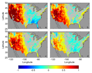
Soil moisture can affect the atmosphere by influencing fluxes of heat and moisture originating at the land surface, which can alter atmospheric temperature and humidity and potentially lead to rainfall. However, the land and atmosphere are highly coupled and linked by a vast number of complex, interdependent processes, so it can be difficult to disentangle this influence. Identification of causal relationships in the land-atmosphere system is important in order to inform construction and testing of physical models (e.g., land surface and climate models), weather prediction, and drought forecasting. Our group has used statistical methods to identify soil moisture-precipitation feedbacks from observational data, accounting for confounding factors that could cloud identification of this relationship.
Plant functional traits and climate influence drought intensification and land-atmosphere feedbacks. (2019). William Anderegg, Anna Trugman, David Bowling, Guido Salvucci, & Sam Tuttle, Proceedings of the National Academy of Sciences (PNAS).
Confounding factors in determining causal soil moisture-precipitation feedback. (2017). Sam Tuttle & Guido Salvucci, Water Resources Research.
Empirical evidence of contrasting soil moisture-precipitation feedbacks across the United States. (2016). Sam Tuttle, & Guido Salvucci, Science.
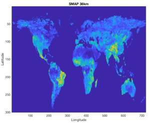
Evaluating Satellite-Derived Soil Moisture
Soil moisture cannot be measured directly from satellites – it must be estimated or inferred from satellite observations. Multiple methods have been developed to make this conversion (i.e. algorithms) and multiple satellite instruments, using different observation techniques and microwave frequencies, have been deployed. It is important to be able to evaluate the soil moisture estimates from these various methods and sensors. Our group has used information theory and large-scale precipitation data to evaluate these data at large scales.
Evaluation of satellite soil moisture datasets using mutual information with precipitation. (2019). Sam Tuttle & Guido Salvucci. 2019 AGU Fall Meeting, San Francisco, CA.
A new approach for validating satellite estimates of soil moisture using large-scale precipitation: Comparing AMSR-E products. (2014). Sam Tuttle & Guido Salvucci, Remote Sensing of Environment.
Monitoring Lake Ice Cover Timing
Lakes are sensitive climate indicators. Lake ice timing has been recorded for over a century, but in recent decades satellites have greatly increased the capability of monitoring lake ice, especially in remote areas. However, satellite observations are not often ground-truthed with in-situ measurements and direct observations. Our group has compared estimates of lake ice duration from satellite data (MODIS, Sentinel-1) with continuously monitored lake water temperature and photographs from automatic cameras Lake Linné, Svalbard.
Evaluation of Satellite-Derived Estimates of Lake Ice Cover Timing on Linnévatnet, Kapp Linné, Svalbard Using In-Situ Data. (2022). Sam Tuttle, Steven Roof, Michael Retelle, Alan Werner, Grant Gunn, & Erin Bunting. Remote Sensing.
Evaluation of satellite-derived estimates of lake ice cover timing on Linnévatnet, Kapp Linné, Svalbard using in-situ data. (2020). Samuel Tuttle, Steven Roof, Jin Cao, Alan Werner, & Michael Retelle, SIOS’s Online Conference on Earth Observation (EO), Remote Sensing (RS), and Geoinformation (GI) applications in Svalbard.
Comparison of Arctic lake ice cover timing on Svalbard using satellite and in-situ data. (2018). Jin Cao, Sam Tuttle, Steven Roof, Grant Gunn, Erin Bunting, & Alan Werner, AGU Fall Meeting, Washington, D.C.
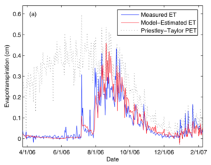
Estimation of Evapotranspiration at Large Scales
Understanding of large-scale evapotranspiration (ET) is crucial for water resources management and agricultural planning, ecological analyses, and weather and climate modeling. But, good quality ET records are sparse and short (usually less than 20 years). Our group developed a method to predict evapotranspiration at the scale of a watershed using the water balance and only records of precipitation, streamflow, and a few meteorological variables (i.e. without calibration to measured ET).
A new method for calibrating a simple, watershed scale model of evapotranspiration: Maximizing the correlation between observed streamflow and model inferred storage. (2012). Sam Tuttle & Guido Salvucci, Water Resources Research.